


US Topo Maps
4.62.24K Reviews
App Specs
- Version
- 7.8.9
- Updated On
- License
- Free
- Downloads
- 1,000,000+
- Developer
- ATLOGIS Geoinformatics GmbH & Co. KG
- Categories
- Maps & Navigation
- Platform
- Android
Screenshots
 Analysis by AppCompare
I like to think of US Topo Maps as a field tool rather than a turn-by-turn navigator. That distinction matters: when I’m exploring public trails, checking the shape of a hillside, or comparing a paper map with my phone, a map-focused app can be more useful than directions designed for driving. US Topo Maps is an outdoor and navigation app from ATLOGIS Geoinformatics GmbH & Co. KG, and its mix of map styles is aimed at people who want to inspect the landscape, not just get from one address to another.
Its audience is fairly specific. Hikers, campers, anglers, and people who work or travel in rural areas may appreciate having topographic, aerial, and nautical chart options in one place. If your usual need is finding a restaurant or avoiding traffic across town, a mainstream road-navigation app will probably be quicker and simpler. I see this one as a companion for planning and orientation, not a replacement for every map on my phone.
Getting Started with US Topo Maps
First things first, downloading US Topo Maps was a breeze. It's available on both Android and iOS, so no one misses out. When you open it, you're greeted with a clean, user-friendly interface. I was immediately impressed by how intuitive it is. No need to read lengthy manuals – just dive right in!
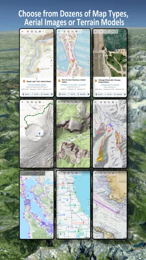
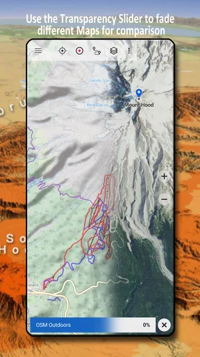
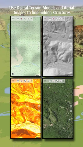
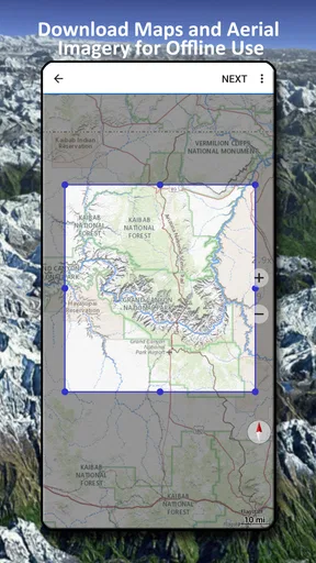
The app is packed with an array of maps, including topographic, satellite, and terrain views. Whether you're planning a hiking trip, a camping weekend, or just want to explore new routes, this app has got you covered. You can even download maps for offline use, which is a lifesaver when you’re out in the wilderness with no signal.
Features That Stand Out
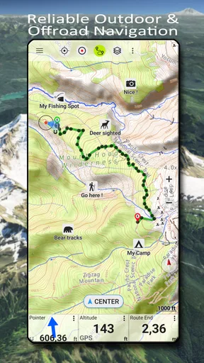
One of the standout features of US Topo Maps is its ability to track your location in real-time. This is perfect for anyone who tends to wander off the beaten path. Just tap into the GPS functionality, and you’ll see your current position on the map, ensuring you never lose your way.
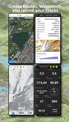
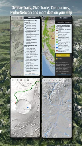
The app also allows you to mark waypoints and create routes. I found this particularly useful for planning my hiking trips in advance. You can even share these routes with friends, making group adventures easier to coordinate.
Another feature I love is the weather integration. Knowing what kind of weather to expect can make or break an outdoor trip. With this app, you can get up-to-date forecasts for your area, helping you prepare for whatever Mother Nature throws your way.
Worth Reading Before You Choose

EA SPORTS FC Mobile 26 Is a Bigger Football Game, but It Takes Time

Flipboard Shows What News Apps Must Do Beyond the Feed

Switching to Android Auto Means Rethinking Your Driving Routine

Google Calendar Makes a Crowded Week Easier to Manage

Ludo King Makes the Most of the Minutes Between Plans

Baby Panda World Brings Quick Play to Modern Phones, but Its Game Library Feels Busy
Planning a route that works in the field
A useful way to prepare is to study the route at more than one zoom level. I first look at the broad area to understand where a trail sits in relation to roads and nearby terrain, then zoom in to examine turns, slopes, and likely stopping points. Topographic contours can help me notice that a route climbs steadily even when the line on the screen looks short. Aerial views, by contrast, give a different visual clue about the land. Neither view is a guarantee that a path is open or passable, so I treat them as planning aids rather than a live report from the ground.
Waypoints become more useful when I give them a purpose before I set out. Instead of dropping pins at random, I might mark a trailhead, a junction where I need to choose a direction, and a planned turnaround point. That creates a simple set of checkpoints I can consult without constantly rebuilding the route. For a group walk, agreeing on recognizable waypoint names before sharing a route can also prevent confusion when everyone is looking at the same map but describing places differently.
What Makes It Unique?
For me, what sets US Topo Maps apart is its comprehensive database. The app covers a vast range of locations across the United States, and the level of detail is incredible. You’ll find everything from national parks to obscure trails you never knew existed.
It also supports different coordinate systems, which is handy if you're working with various types of maps or GPS devices. Plus, the ability to customize map overlays is a fun feature for those who like to tailor their map views.
Where setup and map choices can trip you up
The first decision I would make is not which route to follow, but which map view answers the question I have. A topographic map helps me read elevation and land shape; an aerial image can make visible features easier to recognize; nautical charts are relevant to a different kind of outing. Switching views can be helpful, but it can also make the display feel unfamiliar if I change styles halfway through planning. I try to settle on a primary view, then use another as a cross-check rather than expecting every layer to communicate the same information.
Offline preparation deserves a deliberate check. Before leaving a reliable connection, I would open the area I intend to visit and confirm that the map I need is available for offline use. I would also check the phone’s free storage before saving a large region. If a map does not appear as expected, I would first check that I selected the right location and map style, then review the offline area and storage space rather than assuming the location feature itself is broken. A saved map is useful, but it does not replace carrying a backup plan for a serious trip.
For a practical day hike, I might check the trailhead and the surrounding roads the evening before, save the relevant map area, and mark a meeting point in case the group gets separated. In the morning, I can use the live position marker to orient myself while still following the agreed route. That workflow is more reliable than waiting until the trail loses signal to start figuring out what I should have downloaded.
Things to Keep in Mind
While I’m a big fan of US Topo Maps, it’s worth mentioning that some features require a subscription. However, the basic version of the app is quite robust, and you can definitely get a lot of use out of it without spending a dime. That said, if you’re a serious outdoor enthusiast, the subscription might be worth considering for the extra features.
The app is free to install, and optional in-app purchases range from about fourteen to thirty dollars per item. I would explore the free experience first and only pay if a specific extra fits a regular need; an occasional park visit may not justify spending on features used once. It is rated for everyone, has an average rating of 4.6 from around eleven thousand ratings, and has been installed over a million times. Those figures suggest a substantial audience, but they do not tell me whether a particular map area or workflow will suit my trip, so I would test my own routine before relying on it.
Also, because the app offers so much detail, it can be a bit heavy on storage. So, if you're planning to download numerous maps for offline use, make sure your device has enough space.
There is a useful distinction between a map problem and a conditions problem. A position marker can help me understand where my phone is showing me, but it cannot confirm that a trail is open, that a bridge is intact, or that a route is safe in current weather. If the map appears to stop matching what I see, I would pause, compare nearby terrain and landmarks, and avoid pressing onward just because a line is drawn on screen. In unfamiliar country, a paper map, compass, local guidance, and sound judgment still have a place.
Likewise, if the app feels slow or a downloaded area is missing, I would troubleshoot one thing at a time: check the selected map style and location, verify that the offline area was saved, and make sure the phone has room for downloads. If the issue persists, I would restart the app and check again before changing several settings at once. These basic checks cannot fix every device or connection issue, but they help distinguish a setup mistake from a broader problem without wasting time in the field.
Who should choose it, and who should not
I would recommend it most to someone who enjoys studying a route before setting out and wants several kinds of map information close at hand. It is especially appealing if topography is part of the decision: choosing a gentler approach, understanding how a trail relates to surrounding land, or keeping bearings during a walk away from developed roads. A person who regularly visits remote areas may also value the option to prepare an offline map instead of assuming mobile service will be available throughout the outing.
On the other hand, someone who wants automatic spoken directions, traffic avoidance, or effortless address-to-address navigation should start with a road-navigation app. This app’s strengths are map exploration and outdoor orientation, not replacing that familiar driving workflow. It may also be more than a casual park visitor needs if they are happy with a basic map and rarely plan ahead. The trade-off is clear: more map choice and terrain context can mean more decisions about what to display and save.
Compared with a general mapping app, US Topo Maps puts outdoor map types closer to the center of the experience. A general-purpose alternative may be more convenient for businesses, transit, and daily driving, while a dedicated paper map gives a dependable physical reference without relying on a phone display. I would not treat these choices as mutually exclusive. For a backcountry trip, I would use the app to explore and prepare, then bring an appropriate backup rather than making one device responsible for every navigation decision.
The Final Verdict
All in all, US Topo Maps is a fantastic tool for anyone who loves exploring the outdoors. It’s packed with features that are both practical and user-friendly, and its detailed maps are second to none. Whether you're a casual hiker or an adventure junkie, this app is worth checking out.
So, next time you’re planning an outdoor escapade, give US Topo Maps a try. It might just be the companion you didn’t know you needed!
My practical verdict is that I would install it for the kind of outing where terrain and preparation matter, then spend a few minutes setting up the area before leaving home. Its value is less about tapping a button and having every decision made for me, and more about seeing the landscape, keeping useful reference points, and having a map ready when coverage is unreliable. If that is how you like to navigate, it is a strong fit; if you mainly need simple city directions, I would choose a more conventional option.
Pros
- Extensive map coverage for diverse locations.
- Offline access to downloaded maps.
- Detailed topographical information available.
- User-friendly interface with easy navigation.
- Regular updates enhance map accuracy.
Cons
- Large file sizes for offline maps.
- Battery consumption can be high.
- Limited customization for map views.
- Ads in the free version can be intrusive.
- Requires internet for initial map downloads.
FAQs for US Topo Maps
What features does US Topo Maps offer?
US Topo Maps provides detailed topographic maps of the United States, ideal for hikers, campers, and outdoor enthusiasts. The app includes features such as offline map access, GPS tracking, route planning, and customizable waypoints. Users can also access elevation data, satellite views, and weather updates to enhance their outdoor experiences.
Is US Topo Maps available for both Android and iOS devices?
Yes, US Topo Maps is available for download on both Android and iOS platforms. The app is designed to provide a seamless experience across different devices, ensuring that users can access topographic maps and navigation features, regardless of their chosen operating system.
Does US Topo Maps work offline?
US Topo Maps offers offline functionality, allowing users to download maps for use without an internet connection. This is particularly useful for outdoor activities in remote areas where network coverage might be limited. Users can pre-download the necessary maps and access them anytime during their adventures.
Are there any subscription fees or in-app purchases in US Topo Maps?
US Topo Maps offers a free version with basic features. However, there are optional in-app purchases and subscription plans that provide access to premium features such as advanced route planning, additional map layers, and ad-free usage. Users can choose a plan that best fits their needs.
How accurate and up-to-date are the maps in US Topo Maps?
The maps in US Topo Maps are sourced from reliable data providers and are regularly updated to ensure accuracy. The app uses high-resolution topographic maps that reflect the latest geographic and topographic information, helping users navigate effectively in various terrains across the United States.


